
 18208
18208


Lombok Earthquake 2018
Preface
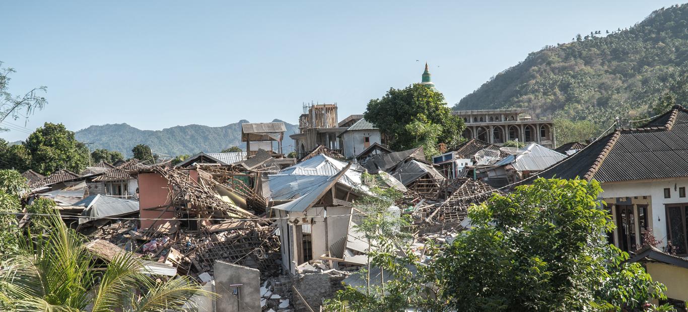
As we all know, Lombok was hit by large earthquakes. Recorded on August 11th 2018 at 07.00 WIB, there were 521 aftershocks from the M 7.0 earthquake (August 5th 2018), and 21 of them were felt. As of August 12th 2018, 392 people had died. The following is an explanation of several major earthquakes that occurred (M> 5.5):
1. The First Earthquake
On July 29th 2018 at 6:47 WITA, precisely at the epicentre position of 8.16 south latitude and 116.4 east longitude or 47 km northeast of Mataram City, West Nusa Tenggara Province, Lombok island was hit by an earthquake measuring 6.4 M at a depth of 13 km. As of August 4th, 564 aftershocks were recorded, with large earthquakes (M> 4.5) 4 times. This incident resulted in minor damage to 825 housing units and serious damage to 534 units, resulting in an economic loss of 34.95 billion, 10 casualties, and 40 injured victims.
Figure 1. Damage Intensity of Lombok Earthquake 2018
Source: BMKG
2. Second Earthquake
On August 5th 2018 at 19.46 WITA, Lombok was shaken again by an earthquake with a greater strength at 7.0 M with an epicentre position of 8.3 LS and 116.48 East Longitude, or precisely at a distance of 18 km northwest of East Lombok Regency at a depth of 15 km.
Just like the previous earthquake, this earthquake was an upward fault. However, because this fault has a large rake (the angle formed between the fault) and a continuous plane to the seabed, the tsunami occurred even though the epicentre is on land.
BMKG had issued a tsunami early warning when the highest sea level was <0.5m. Following was tsunami waves in the Carik area as high as 0.135 m, Badas 0.1 m, and Sheet 0.09m.
Figure 2. Tsunami Early Warning for Lombok Earthquake 2018
Source: BMKG
3. Third Earthquake
On August 9th 2018 at 13:25 WITA, an earthquake with a lower strength occurred again at 6.2 M with an epicentre position of 8.47 South Latitude and 116.18 East Longitude, or to be precise at a distance of 6 km northwest of North Lombok at a depth of 14 km. This earthquake has fault characteristics similar to previous earthquakes.
Figure 3. Location of the Lombok Earthquake and Its Magnitude
Image Source: BMKG
A. Losses Due to Earthquakes
The losses from the second Lombok earthquake is still unknown to date. However, the results of an interim survey conducted by BMKG can illustrate the level of damage experienced in the following areas:
-
Mataram = VII MMI
-
Bima = V-VI MMI
-
Karangasem = V-VI MMI
-
Denpasar = V-VI MMI
-
Kuta = IV MMI
-
Waingapu = III MMI
-
Malang = II – III MMI
-
Banyuwangi = II – III MMI
It should be noted that the MMI scale is of damage caused by an earthquake. Apart from being influenced by the magnitude and location of the earthquake, this value is also influenced by the type of rocks and building construction in the area. As an illustration of the severity, following is an illustration of the MMI scale.
Figure 4. Scale of Modified Mercalli Intensity (MMI) on the Impact of Earthquake Damage
Source: BMKG
B. Correlation of the Three Earthquakes
Viewed from the epicenter position, hypocenter depth, and the source mechanism, the three earthquakes were probably a series of earthquakes. The incident on July 29th was a Foreshock, August 5th was the main earthquake (Mainshock), and August 9 could possibly be an Aftershock.
The second earthquake can be said to be a mainshock because this earthquake has the greatest magnitude of the three. The three earthquakes were generated as a result of the Flores Back Arc Thrust activity. This is evidenced by the strike (direction of the fault) in the direction of the back arc thrust flores itself. Historically, this rising fault has caused the Seritit earthquake in 1976 and Flores 1992.
Figure 5. Location of the Flores Back Arc Thrust
Source: esdm
This earthquake event is unlikely to trigger the South Java - Sunda Strait Megathrust earthquake, because the source of the Lombok earthquake is a different earthquake source (active fault) while the southern Megathrust of Java is affected by a subduction zone which is quite far away.
C. Our (Indonesia Re) Readiness
As a national reinsurance company, Indonesia Re has an exposure of more than US $ 1 billion in the Cresta 8 zone, with the majority in Bali and Lombok. In order to ensure safe recovery for ceding companies, currently Indonesia Re has protection of US $ 400 million. With this capacity, Indonesia Re is able to bear the worst-case scenario earthquake claim event.
From a Treaty view, please pay attention to the event limit and Hours Clause that apply to each contract. This can cause variations in the calculation of recovery to adjust to the two clauses.
This value can be bigger if the accumulated data update as of July 31st 2018 that has been successfully completed and the aftershocks continue with a large magnitude value.
Author

Ramadhan Kautsar, ST., AAAIK
Email: ramadhan@indonesiare.co.id
Artikel
- Penggunaan Annual Aggregate Deductible dalam kontrak Treaty Excess of Loss
 04 Mar 2022
 5999 kali
 - Gunung Api di Indonesia dan Bahaya yang ditimbulkan22 Oct 202122100 kali
- Mengenal CRESTA Zone dalam Industri Perasuransian16 Apr 20219070 kali
- Respon Treaty terhadap aftershock & mainshock pada Gempa Majene04 Feb 20217606 kali
Follow Us


