
 14641
14641


Donggala 2018: Earthquake, Tsunami, and Liquefaction
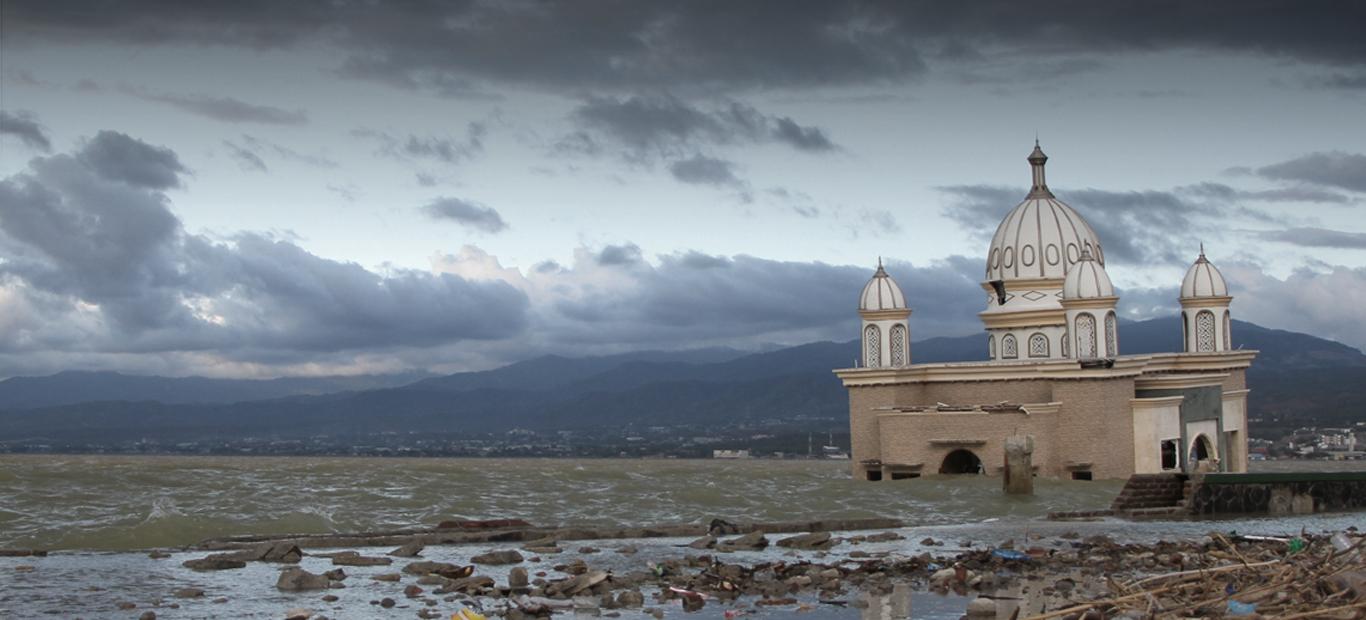
We can not forget the year 2018 when Indonesia was hit by many catastrophic events, one of which was the Donggala earthquake on September 28th 2018. This earthquake was a large scale earthquake (M 7.4) and caused a tsunami. Based on the Willis Re eVENTTM Update on Natural Catastrophe Events 2018, the Donggala earthquake was recorded to have an economic loss of 966 million USD and the fatality of 2256 people.
The earthquake was generated as a result of the Palu Koro fault activity. This fault is a strike slip fault meaning the direction of movement of the fault is lateral. The Palu Koro fault is one of the active faults in Indonesia. The fault moves about 7cm per year. Historically, this fault has often caused earthquakes, both small and large scale, including the Bora earthquake (2005), the Rano earthquake (1998), and the Tonggolobibi earthquake (1996).
Despite having an earthquake source on land, this earthquake also caused a tsunami in Palu as high as 3 metres. It was recorded that until October 1st 2018, aftershocks were still ongoing with great strength, around M6.3. This type of fault does not cause a tsunami, however, because the movement of the fault causes an underwater slope to slide, a tsunami can occur. Although tsunamis caused by underwater landslides generally do not have an impact as large as a tsunami due to the movement of the fault, due to the geographical conditions of the city of Palu, which is located in the bay, the amplitude of the tsunami waves is estimated to be amplified and eventually hit the land.
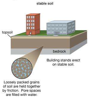
Figure 2. Soil conditions with a lot of groundwater before liquefaction
Source: britannica.com
Figure 3. Soil conditions after liquefaction
Source: britannica.com
Not only the tsunami, the Donggala earthquake also caused liquefaction. This disaster was caused by the regional geological conditions of Palu which were in alluvial soil conditions. It should be noted that alluvial soils are unconsolidated (not compact) and easily store water. Figure 2 and Figure 3 explain how an area can be affected by liquefaction. In normal conditions, the land in Palu area is still compact and able to support the buildings above it. When a sufficiently large water supply (tsunami) occurs, the land will be filled with water (groundwater) which has a large enough volume. This causes the land to lose its compaction even though it can still support the buildings on it (Figure 2). The peak occurs when the earthquake shakes the area, this causes the soil grains to loosen from one another, the adhesive power between the grains is lost, and causes "mud" that almost inundates one village (Figure 3).
The results of an interim survey conducted by BMKG can illustrate the extent of the damage experienced in the following areas:
-
Donggala = VII-VIII MMI
-
Palu = VI-VII MMI
-
Poso = III-IV MMI
-
Soroako = III MMI
-
Kolaka = II-III MMI
-
Makassar = II MMI
-
Toraja = II MMI
Note that the MMI scale is the scale of damage caused by an earthquake.
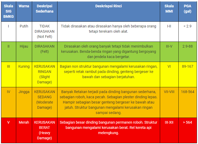
Table 1. Earthquake MMI intensity scale
Source: bmkg.go.id
Lesson learned from this rare incident in Indonesia? These three events occur in just a matter of hours from one event to another. As an insurance actor, you should prepare sufficient catastrophic cover for disasters like this. Because of a disaster like this, liquefaction is especially likely to occur in areas with high exposure, such as in DKI Jakarta.
Author

Mordekhai, ST., MT.
Email: mordekhai@indonesiare.co.id
Artikel
- How we know the layers of the earth that can not be penetrated by drilling?
 12 Aug 2019
 70013 kali
 - How Come Kalimantan Got Hit by an Earthquake?18 Jun 201913172 kali
Follow Us


