
 13171
13171


How Come Kalimantan Got Hit by an Earthquake?
.JPG)
Figure 1 Bulungan Earthquake June 11th 2019
Perhaps many have not realized that on June 11, 2019 there was an earthquake in Bulungan, North Kalimantan with a magnitude of 4.7. This earthquake was reported to have caused MMI II-III scale damage in Tanjung Selor, the capital of North Kalimantan. The MMI strength scale is the scale of earthquake shocks felt in a certain area. An illustration of the MMI power scale can be seen in Figure 2.
.JPG)
Figure 2 An overview of the MMI power scale
The big question is: “How come Kalimantan got hit by an earthquake? With a magnitude above 4.5?" Based on the intensity scale (MMI), the damage was insignificant. However, it is not impossible that there will be a bigger impact in the future, if many tall buildings are built in the area
Kalimantan, which is always predicted to have an area that is not prone to earthquakes and is far from the ring of fire, makes it one of the factors that the state capital will move to one of the cities on the island. So back to the original question, "How come Kalimantan was hit by an earthquake?"
.JPG)
Figure 3 History of the Indonesian earthquake 1964-2000
Historically, Figure 3 shows that earthquakes occurred in the Sumatra-Java and extended towards the Philippines. As is well known, this is actually caused by a very long plate subduction route in west Sumatra / South Java. At first glance, Kalimantan does have a bit of an earthquake past, but is it really free from big earthquakes and broken fragments?
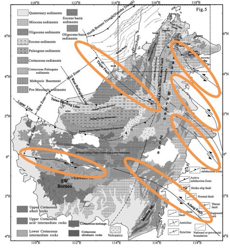
Figure 4 Faults in Kalimantan Island
If we look deeper, Figure 4 shows that Kalimantan has a lot of broken fragments/ faults. It can be seen clearly that this fault line is long and crosses the island of Borneo. Regardless of whether this fault is active or not, what is certain is that every fault has experienced pressure and is likely to still store "energy" that could have accumulated. Looking at the many Kalimantan faults, what about the earthquake historical data?
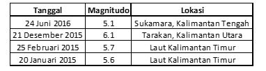
From Table 1 it can be seen that in the last 5 years, Kalimantan has not been spared from major earthquakes and one of them has a magnitude above 6. Even though it has a large earthquake that is more "quiet" than in Java or Sumatra, Kalimantan is not completely free from earthquake threats, especially when there are still small-scale earthquakes like the one that occurred on June 11th.
Table 1 M>5 Earthquake at Kalimantan in the last 5 years
From this article, the writer concludes that it is not quite right to say that “Kalimantan is an earthquake-prone area in Indonesia”, perhaps it is better to say that “Kalimantan is a relatively earthquake-prone area in Indonesia”. I think this is more appropriate because you can see for yourself that even Kalimantan is not completely free from the earthquakes that are always lurking.
Further on, saying this intends to have an impact so we don’t override our awareness of the earthquake in Kalimantan.
“the key to surviving a disaster is to be alert to a disaster”
Reference:
Hall, et al. 2008. The Geology of Mount Kinabalu. p.6.
Wang, et al.2016.Geological Journal SI. p. 464-489.
********
Author

Mordekhai, ST., MT.
Email: mordekhai@indonesiare.co.id
Artikel
- How we know the layers of the earth that can not be penetrated by drilling?
 12 Aug 2019
 70013 kali
 - Donggala 2018: Earthquake, Tsunami, and Liquefaction04 Feb 201914641 kali
Follow Us


